

Celebrate the 4th of July in Munising, MI
Get ready for one of the most iconic Independence Day celebrations in the U.P.! From a festive 5K and patriotic parade to games in the park, live music, and fireworks over the bay, Munising’s 4th of July celebration is full of family fun, small-town charm, and Lake Superior views. Come for the day, or stay

Top 5 Flowing Waterfalls in Munising this Spring
Spring is the time of fresh starts and new beginnings. In Munising, a perfect example of this season of change is our waterfalls! As the snow melts and the April rains pour in, waterfalls surge to life with roaring waters, creating ideal viewing conditions. The sound of rushing water, the warm sun poking through the
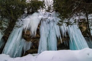
Exploring Munising’s Winter Waterfalls & Frozen Formations
When winter hits Munising, we don’t hibernate, we celebrate! The Pictured Rocks landscape transforms into a winter wonderland of ice sculptures, frosted forests, and pure U.P. magic. Waterfalls freeze into glistening pillars, sandstone cliffs grow icy curtains, and hidden caves glow in shades of blue and gold. Whether you’re looking for a thrilling ice climbing

Winter Activities You Don’t Want to Miss in Munising
Each year, Munising hosts the Michigan Ice Fest, a celebration of climbing that brings unique outdoor adventure opportunities to everyone from beginners to professional-level athletes. The 2026 Michigan Ice Fest is over, but there is still so much fun to be had in Munising this winter! Whether you’re making the trip for some ice climbing
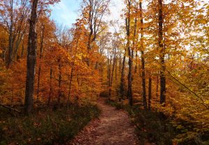
5 Must-Do Fall Hikes in Munising
When autumn arrives in Munising, the forests around Pictured Rocks National Lakeshore explode into beautiful shades of red, orange, and gold. Crisp Lake Superior air, crunching leaves underfoot, and unforgettable overlooks make fall one of the very best times to hike here. Whether you’re looking for low effort and big views or a full-day adventure,

5 Family-Friendly Summer Activities in Munising
Make the most of your summer in Munising with outdoor adventures the whole family can enjoy! Whether you’re traveling with toddlers, teens, or somewhere in between, this lakeside town is full of easy-to-access experiences that let you explore Michigan’s stunning Upper Peninsula, with no intense planning required. From relaxing beach days to unforgettable boat rides,

Get Ready for the Grand Island Trail Marathon
Lace up for one of the most breathtaking trail races in the Midwest! The Grand Island Trail Marathon is more than just a run; it’s a wilderness adventure on Lake Superior’s largest island. With three unforgettable race options, the 50K, Marathon, and Half Marathon, you’ll tackle sandy beaches, shaded forest trails, and jaw-dropping cliffs high

Pictured Rocks Road Race 2025
Sunday, June 29, 2025 Bayshore Park (355 Elm Ave), Munising, MI Get ready for the 50th Annual Pictured Rocks Road Race—a stunning half-marathon, 10K run, and 10K walk winding through the scenic beauty of Munising and along Lake Superior. Runners will enjoy a blend of paved roads and forested two-track trails, including approximately three

Pictured Rocks Days 2025
Get ready for two days of live music, local flavor, and lakeside fun… Pictured Rocks Days is back! Join us at Binsfeld Bayshore Park on Friday, June 13 (3–8pm) and Saturday, June 14 (10am–6pm) for a free community festival you won’t want to miss. Enjoy live bands all weekend long, explore unique arts and crafts