Munising is home of the Pictured Rocks National Lakeshore, Hiawatha National Forest, and Grand Island National Recreational Area in Michigan’s Upper Peninsula. We do outdoors BIG here in Munising—all year ‘round. So, if you’re a veteran of our natural habitats, or if this is your first time in the north country, let this be your guide. We love Munising and we know you’ll love it, too!
EXPLORE THE AREA
Unforgettable
Places
Explore the charming downtown area, where local shops, eateries, and galleries showcase the town’s vibrant personality. Immerse yourself in the rich history and culture of the region, discovering the stories that have shaped Munising into the welcoming community it is today.
Hiking, biking, backpacking, backcountry camping, bird watching – with the 894,836-acre Hiawatha National Forest in our backyard, the woodland pursuits are endless.
The 13,500-acre island addition to the Hiawatha National Forest showcases a rich natural and cultural history and offers a unique educational and recreational opportunity for all.v
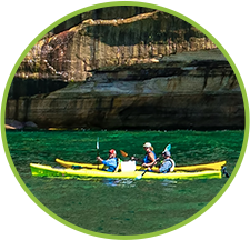
Munising is a hub of activity during the summer months, including guided boat and kayak of the Pictured Rocks, Grand Island, and local shipwrecks. For those who prefer being on land, there are incredible waterfall hikes, magical beaches to relax on, and scenic trails to explore, making it a destination suitable for all ages.
Deep snowpack, frozen waterfalls, Great Lakes icebergs—winters in the Upper Peninsula are the stuff of legend. Whether you’re craving a high-octane snowmobile adventure or a cozy cabin with a roaring fireplace, Munising is the place to go. Let it snow. Let it snow. Let it snow!
Explore the charming downtown area, where local shops, eateries, and galleries showcase the town’s vibrant personality. Immerse yourself in the rich history and culture of the region, discovering the stories that have shaped Munising into the welcoming community it is today.
No matter what time of year you plan to travel to Munising, it’s best to plan to ensure your vacation goes as smoothly as possible. But don’t worry, we have all the resources you need.
Whether you want to snowmobile, view some of the most beautiful fall foliage in America, or relax on a magical beach, Munising’s four seasons have something for everyone.
While its rural location is part of the charm, cell service can be an issue for some arriving in the Upper Peninsula. Fortunately, we have a range of maps and guides to help you along the way.